← Home · Slopes & Walls

Slope Stability Analysis for Wellington's Demanding Terrain

Together, we solve the challenges of tomorrow.

LEARN MORE →

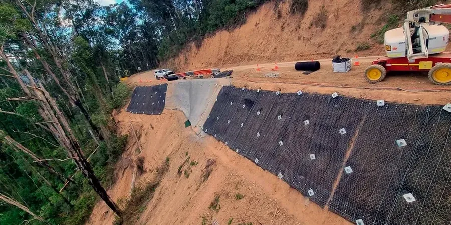
Wellington’s topography doesn’t offer gentle building sites—it demands respect. The city straddles steep ridges carved into weathered greywacke and mantled with loess, all exposed to relentless Cook Strait winds and 1,200 mm of annual rainfall. When a developer prepares a cut platform in Karori or widens an access road above Ngaio Gorge, the margin between a stable batter and a costly slip often comes down to a few degrees of inclination. Our team applies in-situ permeability testing to quantify pore pressure response during storm events, building a groundwater model that informs every stability calculation. The New Zealand Geotechnical Society guidelines require solid investigation before design, and that framework shapes how we approach each fractured, dipping rock slope across the region.

A slope that stands for twenty years can fail in twenty seconds when groundwater pressures spike during a southerly storm.

Our approach and scope

Wellington experiences roughly 100 mm of horizontal tectonic movement every year along the plate boundary, which keeps the local bedrock in a persistently stressed state. Unlike the massive basalt flows of Auckland, the Wellington Peninsula is dominated by Torlesse greywacke that fractures along closely spaced joint sets, creating wedge failures where daylighting planes align unfavorably with a proposed excavation. We combine kinematic analysis with limit-equilibrium modeling to isolate these critical joint intersections, often supplementing rock mass classification with seismic refraction profiles that map the depth of weathered material across a building platform. A typical investigation drills into the bedrock to recover oriented core, logs fracture frequency and infill condition, then correlates those observations with laboratory-derived shear strength parameters for each distinct material unit.
Slope Stability Analysis for Wellington's Demanding Terrain
Technical reference image — Wellington

Local ground factors

The most frequent mistake we see on Wellington sites is treating the weathered zone as a uniform material rather than a progressive weathering profile. A contractor cuts a 70-degree face through orange-brown oxidized greywacke, assumes it will stand unsupported through winter, then watches raveling develop into a full-scale wedge failure after a week of heavy rain. The interface between residual soil and highly weathered rock acts as a perched aquifer, and without drainage measures specified from the stability model, pore pressures build behind the face until the effective stress drops below the failure envelope. Another recurring problem is neglecting the influence of earthquake-induced strength loss in sensitive silts found on older terraces around the Hutt Valley.

Need a geotechnical assessment?

Reply within 24h.

Email: [email protected]

Typical values

ParameterTypical value
Analysis methodLimit equilibrium (LEM) + finite element (FEM) where complex geometry demands
Slip surface searchCircular, block, and fully specified non-circular surfaces per NZGS guidelines
Groundwater modelSteady-state phreatic surface calibrated to piezometer readings
Seismic coefficient (kh)Derived from NZS 1170.5 site-specific hazard spectra
Minimum Factor of Safety (static)1.5 for long-term drained conditions
Minimum Factor of Safety (seismic)1.0–1.2 pseudo-static, dependent on consequence class
Rock mass inputGeological Strength Index (GSI) from face mapping and core logging

Complementary services

01

Soil Slope Investigation & Stability Modeling

Targets colluvium-filled gullies and loess-mantled hillslopes common across the western suburbs. We advance boreholes with SPT sampling to define the soil profile, install standpipe piezometers to monitor seasonal groundwater fluctuation, and run consolidated-undrained triaxial tests on undisturbed samples. The resulting strength envelope feeds a limit-equilibrium model that tests circular and non-circular failure surfaces under both drained and undrained loading scenarios.

02

Rock Slope Kinematic & Numerical Analysis

Designed for cut faces in greywacke where joint orientation, persistence, and infill dictate stability. Field mapping records dip, dip direction, spacing, and roughness for each joint set. Stereographic projection identifies potential wedge and planar failure modes. Where block size and geometry demand it, we build a distinct-element model to simulate block displacement under seismic loading, providing the design team with reinforcement specifications tied directly to joint network geometry.

Regulatory framework

NZS 4404:2010 Land Development and Subdivision Infrastructure, NZS 1170.5:2004 Structural Design Actions – Earthquake Actions, NZGS (2005) Field Description of Soil and Rock Guideline, NZGS (2018) Earthquake Geotechnical Engineering Practice Guidelines

Common questions

What does a slope stability analysis typically cost for a residential building site in Wellington?

For a typical single-dwelling platform on a Wellington hillside, a site-specific stability assessment including geological mapping, a borehole or test pit investigation, laboratory strength testing, and a limit-equilibrium model generally falls between NZ$2,140 and NZ$6,330. The spread depends on access constraints, depth of investigation required, and whether the slope falls into a higher consequence category under NZGS guidelines. Complex sites with multiple failure modes or those requiring finite-element analysis sit toward the upper end of that range.

How far back from the top of a slope should a building platform be set in Wellington's terrain?

There is no fixed setback distance that works across the region. The required offset depends on the height and angle of the slope, the shear strength of the material, the groundwater conditions, and the seismic hazard at the site. Our analysis calculates the critical failure surface for the specific geometry and soil or rock profile, then applies the appropriate factor of safety to define a stable setback. Wellington City Council typically requires a geotechnical assessment demonstrating a minimum static factor of safety of 1.5 before issuing building consent on sloping sites.

Does a slope stability analysis need to consider earthquake loading in Wellington?

Absolutely. Wellington sits astride the active Wellington Fault and lies within a high-seismicity zone. NZS 1170.5 and the NZGS earthquake engineering guidelines require pseudo-static analysis using a horizontal seismic coefficient appropriate to the site subsoil class and importance level. For critical slopes or those supporting structures with post-disaster function, we often supplement the pseudo-static check with a Newmark displacement analysis to estimate permanent deformation during the design earthquake, giving the structural engineer a basis for assessing tolerable movement.

Location and service area

We serve projects in Wellington and surrounding areas.

View larger map